OGO, 17. - 20. 3. 2022: NOT AT Alpstein. FINAL Info Friday Noon
Die Prognosen sind zu unterschiedlich, um heute einen Ort zu definieren. Definitive Info Freitag Mittag.
Sicher ist, dass wir nicht in den Alpstein (OGO, Wasserauen) gehen. Dort ist der Wind am Samstag zu stark, und am Sonntag kann es länger bewölkt sein.
Wir suchen eine Alternative. Sei dies Engelberg oder Grindelwald, das Wallis (Crans Montana) oder Surselva (Flims). Um einen Ort jetzt schon zu definieren, ist es wie gesagt zu früh.
Meteo:
Der Kaltlufttropfen geht etwas nördlicher durch als gestern prognostiziert. Die Prognosen sind immer noch unterschiedlich. ICON prognostiziert am Samstag viele Wolken, COSMO am Sonntag ...
Samstag
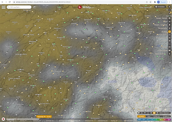
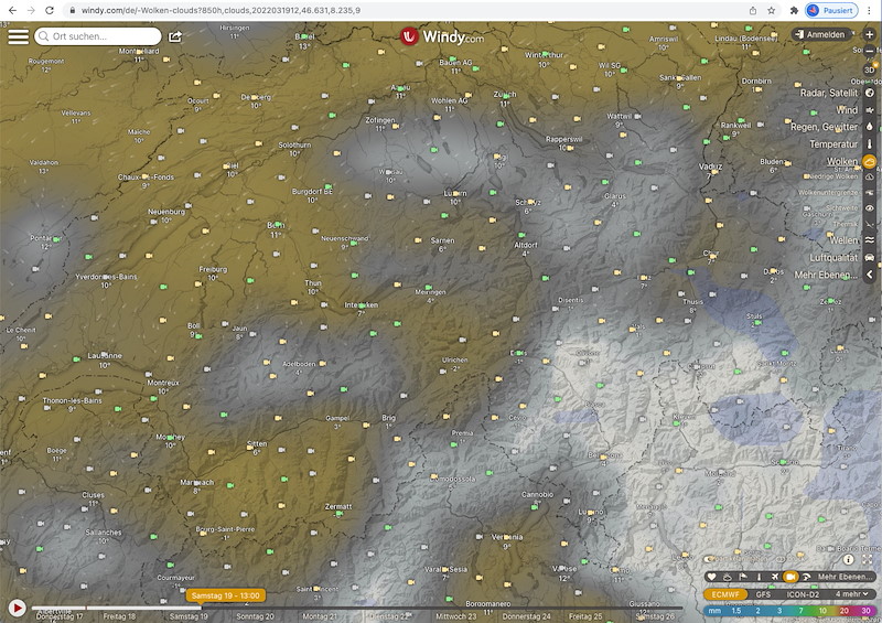
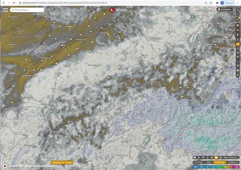
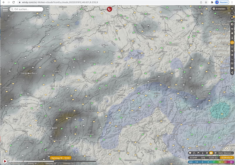
Alpstein zügiger NO (zu stark). Von Südwesten her Bewölkungszunahme, wobei es inneralpin länger schön bleibt. ICON macht am Samstag auf der ganzen Alpennordseite viele Wolken. Gemäss ICON ist am Samstag kein Task möglich. Gemäss COSMO ist es ziemlich schön.
In der Nacht auf Sonntag Störung mit etwas Niederschlag (Jura, westl Voralpen, BEO bis Engelberg und Alpensüdseite).
In der Nacht starker SW-Wind, am Morgen schnell nachlassend.
Sonntag auf der westlichen Alpennordseite noch lange Bewölkt (Jura, Westschweiz bis Alpstein), ineralpin sonniger. Aus Süden tiefe Wolken (Gotthardregion).
5-6hp Druckdifferenz, aber am Tag dennoch wenig Südwind. Im Bodenfeld im Nordosten immer noch Bise.
Bilder: 3 Prognosen für den Samstag, 13h.
**********************************************
**********************************************
Les prévisions sont trop différentes pour définir un lieu aujourd'hui. Info définitive vendredi midi.
Ce qui est sûr, c'est que nous n'irons pas dans l'Alpstein (OGO, Wasserauen). Là-bas, le vent est trop fort le samedi, et le dimanche, le ciel peut être nuageux plus longtemps.
Nous chercherons une alternative. Que ce soit Engelberg ou Grindelwald, le Valais (Crans Montana) ou Surselva (Flims). Pour définir un lieu dès maintenant, il est trop tôt, comme déjà dit.
Météo :
La goutte d'air froid passe un peu plus au nord que ce qui était prévu hier. Les prévisions sont toujours différentes. ICON prévoit beaucoup de nuages le samedi, COSMO le dimanche ...
Samedi
Alpstein, vent du nord-est rapide (trop fort). Augmentation de la nébulosité à partir du sud-ouest, mais le temps reste beau plus longtemps dans les Alpes. ICON fait beaucoup de nuages samedi sur tout le nord des Alpes. Selon ICON, aucune tâche n'est possible samedi. Selon COSMO, il fait assez beau.
Dans la nuit de samedi à dimanche, perturbation avec quelques précipitations (Jura, Préalpes occidentales, BEO jusqu'à Engelberg et Sud des Alpes).
Vent fort de SW pendant la nuit, s'atténuant rapidement le matin.
Dimanche, ciel encore longtemps nuageux sur l'ouest des Alpes (Jura, Suisse occidentale jusqu'à Alpstein), plus ensoleillé dans les Alpes. Du sud, nuages bas (région du Gotthard).
Différence de pression de 5 à 6hp, mais néanmoins peu de vent du sud pendant la journée. Dans le champ de sol au nord-est, toujours de la bise.
**********************************************
**********************************************
The forecasts are too different to define a place today. Definitive info Friday noon.
What is certain is that we will not go to the Alpstein (OGO, Wasserauen). There the wind is too strong on Saturday, and on Sunday it can be cloudy longer.
We are looking for an alternative. Be it Engelberg or Grindelwald, the Valais (Crans Montana) or Surselva (Flims). To define a place now, it is, as I said, too early.
Meteo:
The cold air drop passes a bit more north than forecasted yesterday. The forecasts still vary. ICON forecasts lots of clouds on Saturday, COSMO on Sunday ...
Saturday
Alpstein brisk NE (too strong). Increasing clouds from the southwest, although it will remain fine longer in the inner Alps. ICON makes many clouds on Saturday on the whole northern side of the Alps. According to ICON, no task is possible on Saturday. According to COSMO it will be quite nice.
In the night to Sunday a disturbance with some precipitation (Jura, western Pre-Alps, BEO to Engelberg and south side of the Alps).
Strong SW winds during the night, quickly decreasing in the morning.
Sunday on the western north side of the Alps still cloudy for a longer time (Jura, western Switzerland to Alpstein), ineralpin sunnier. From the south, low clouds (Gotthard region).
5-6hp pressure difference, but still little southerly wind during the day. Bise still in the Bodenfeld in the northeast.


New Comment