Swiss Cup completely cancelt
Der Wetterbericht hat sich seit gestern kaum verändert:
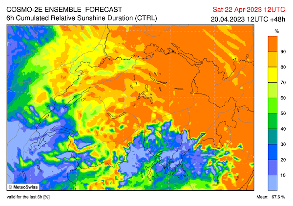
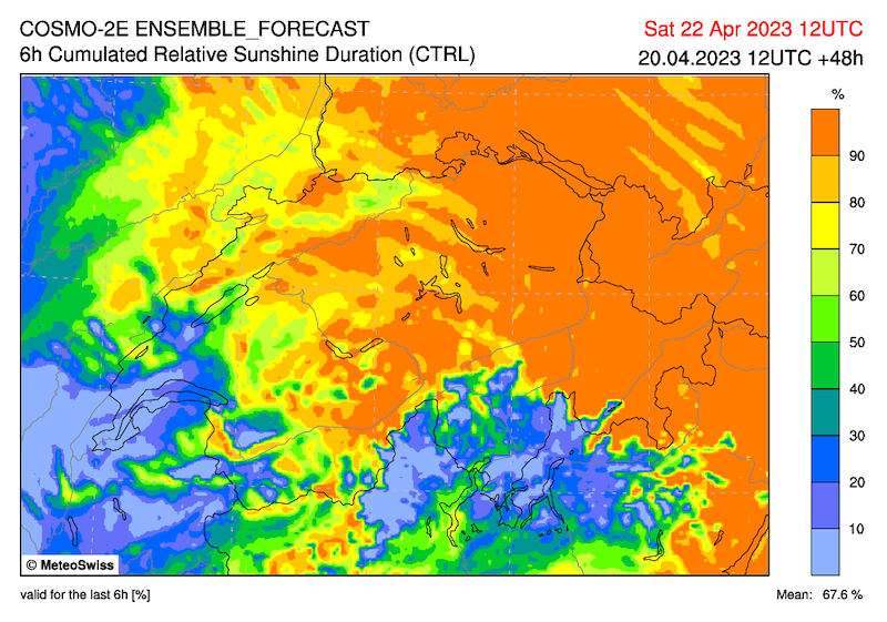
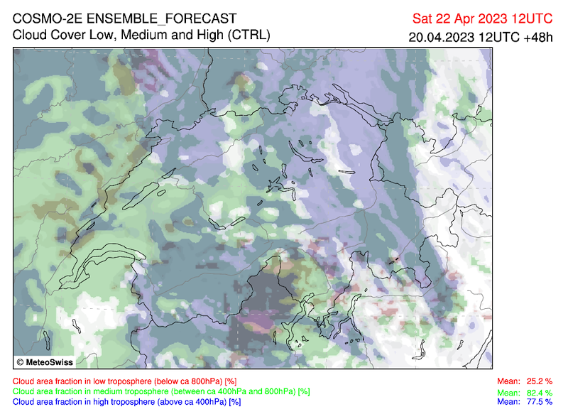
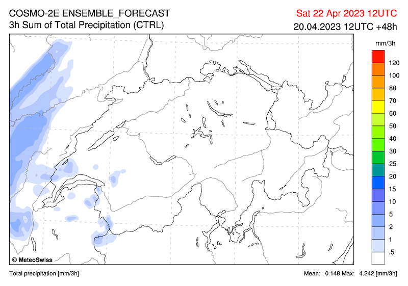
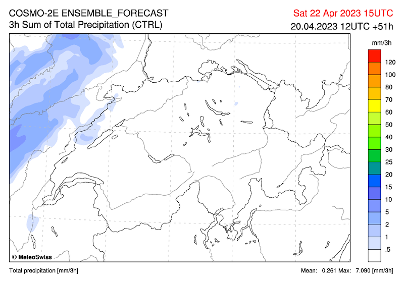
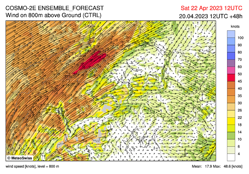
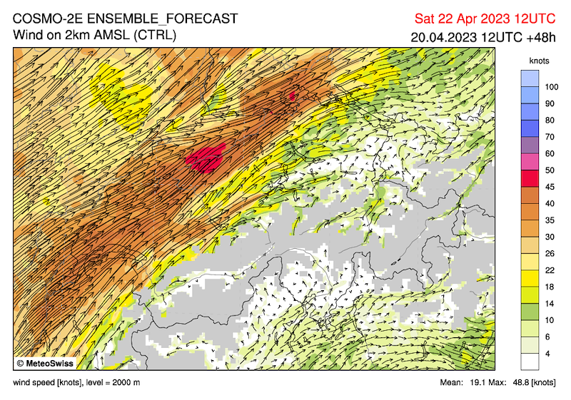
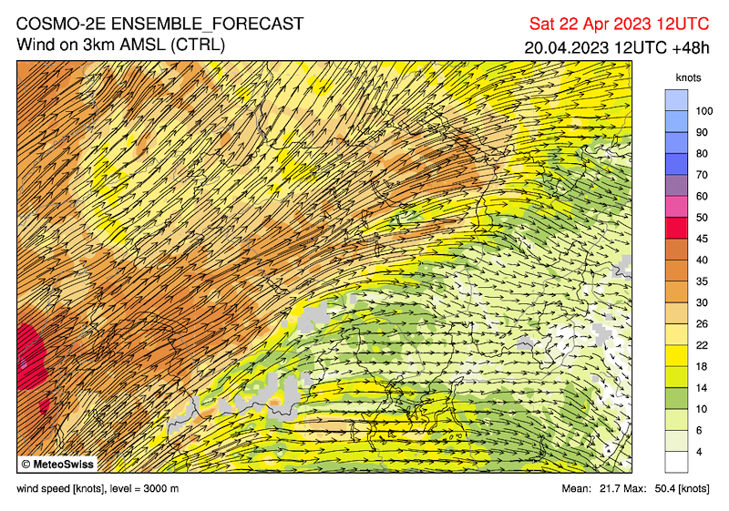
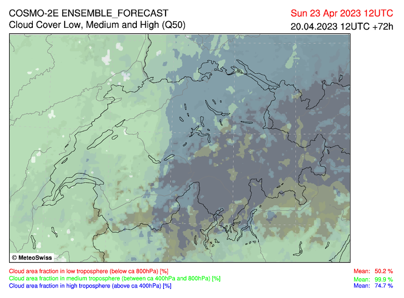
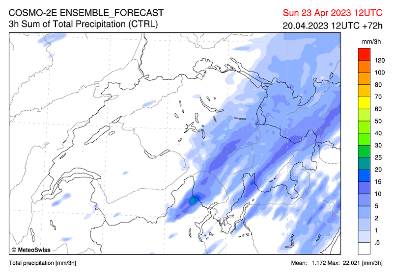
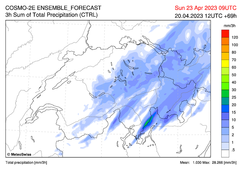
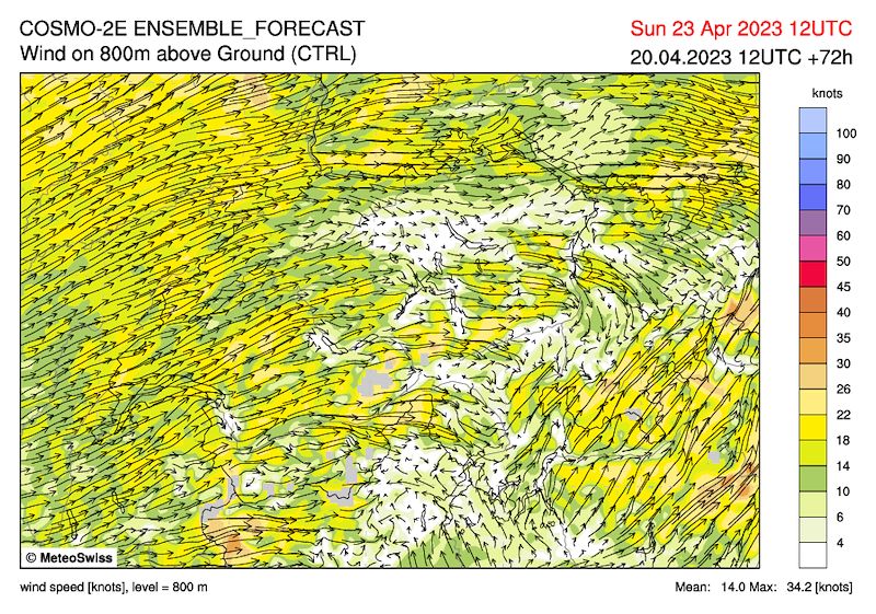
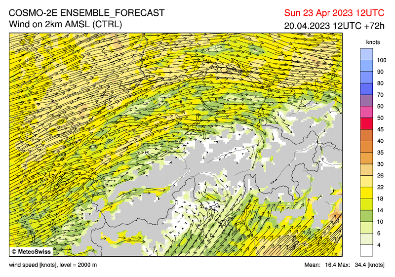
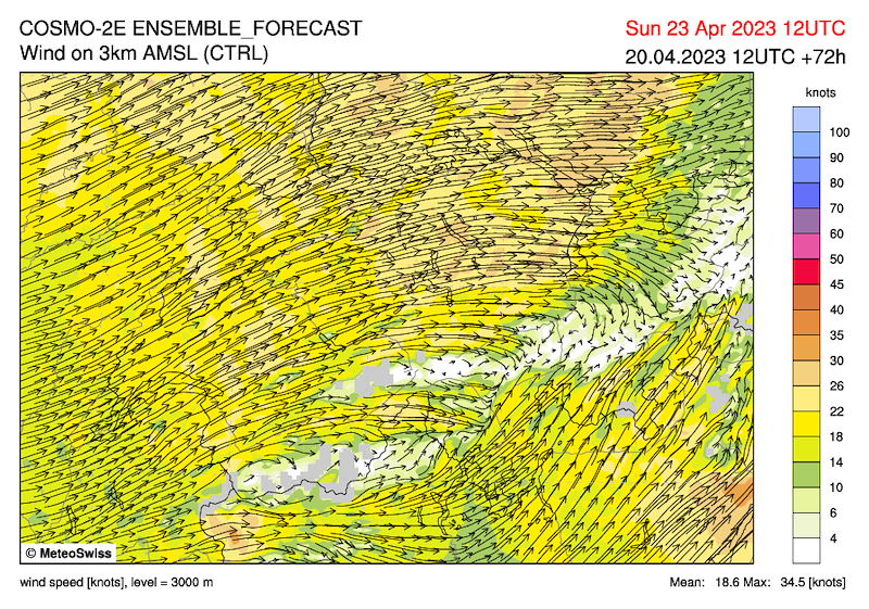
Eine Front überquert die Schweiz Samstag Nacht / Sonntag Morgen. Im Vorfeld hat es viel Bewölkung von Westen her und im Süden, begleitet von starkem Südwestwind.
Locarno/Cimetta:
Samstag stark bewölkt, aber trocken (es hat allerdings in der Nacht auf Samstag geregnet). Kaum Thermikentwicklung wegen Wolken und Feuchtigkeit. In der Nacht und am Sonntag Morgen Regen, vor allem im Südtessin, bis der Nordwestwind am Sonntag Mittag/Nachmittag die Feuchtigkeit wegputzt (Boden wenig Wind aus Süd, oberhalb 1400 Nordwest). Restfeuchte, tiefe Basis und zu viel Wolken.
Alpennordseite:
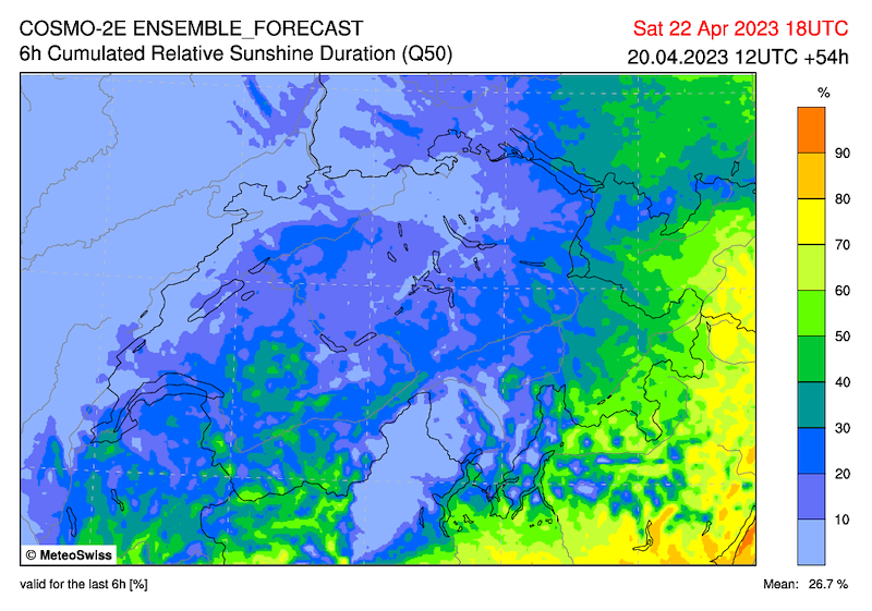
Auf der Alpennordseite ist es am Samstag mit Föhntendenz und starkem Südwestwind noch freundlich, von Westen her aber stark bewölkt. Im Westen am Abend, sonst in der Nacht Niederschlag, der am Sonntag vor allem im Osten und auf der Alpennordseite anhält. Am Sonntag am gesamten Alpennordhang stark bewölkt.
Prognosen für Samstag:
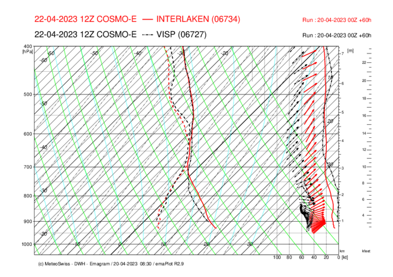
Interlaken:
Am Morgen Föhn, dann aber fliegbar, aber es ist kaum möglich einen vernünftigen Task zu realisieren. Ziemlich stabil und viele Wolken. Beachte den Wind auf 2, 3000m …
Engelberg:
Die Brunibahn hat Revision, aber auch sonst gilt etwa das selbe wie für Interlaken.
Flims / Prättigau:
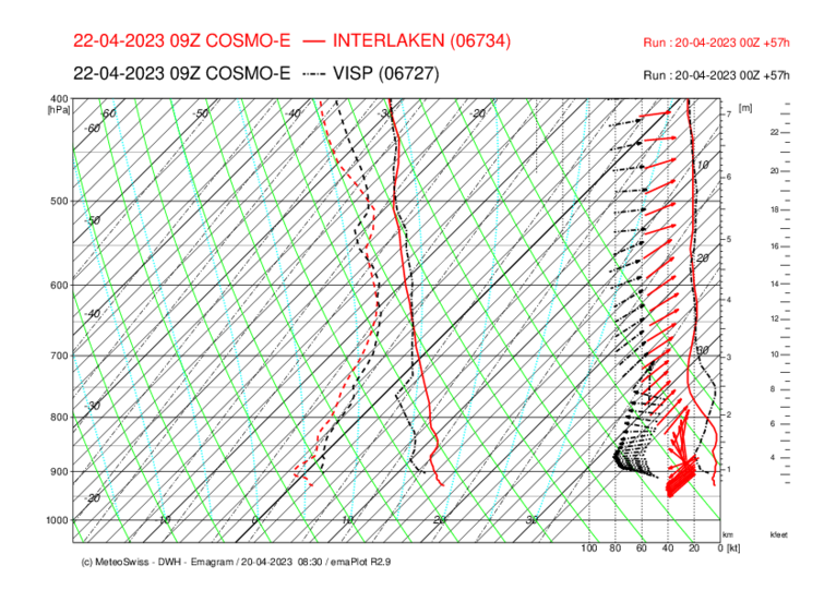
Bei Föhn ist Flims und das Prättigau oft die beste Option. Wahrscheinlich kann dort in der Tat einigermassen angenehm geflogen und kleine Strecken realisiert werden. Für einen Tag können wir aber nicht an den Rand der Schweiz.
Beachte die Prognose für starke Thermik oberhalb von 2500. Dies hat mit dem Einfliessen von kälterer Luft in der Höhe zu tun. Von West (Visp 3 Stunden früher) nach Ost.
Fiesch:
Nach Auflösung der Inversion könnten trotz vieler Wolken kleine bis mittlere Strecken möglich sein. Ev. am Morgen Föhneffekte (Binntal).
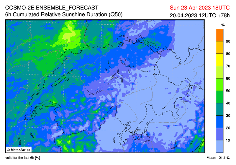
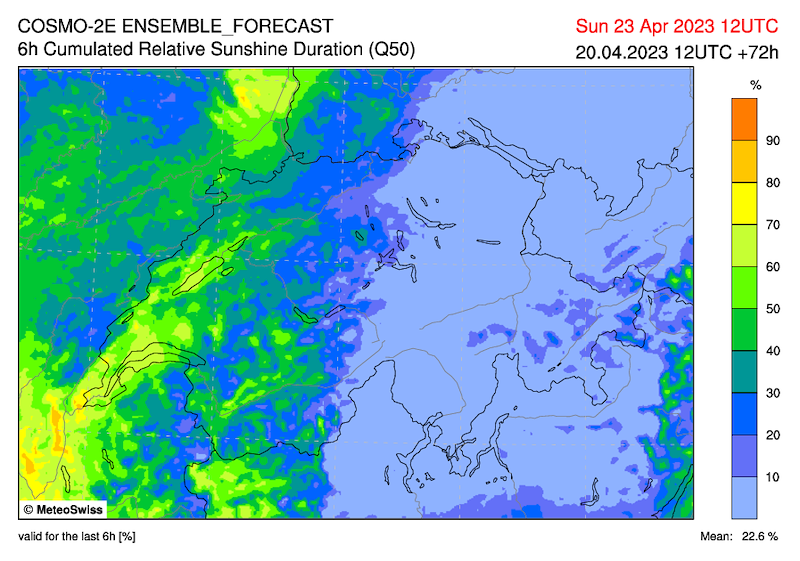
Prognosen für Sonntag:
Fiesch:
Stark bewölkt, tiefe Basis, ab Mittag eventuell Aufhellungen. Ob kleine Strecken möglich sind, ist fragwürdig.
********************************************************************
********************************************************************
Le bulletin météo n'a guère changé depuis hier :
Un front traversera la Suisse samedi soir / dimanche matin. A l'avant, il y aura beaucoup de nuages à partir de l'ouest et dans le sud, accompagnés d'un fort vent du sud-ouest.
Locarno/Cimetta :
Samedi très nuageux mais sec (il a cependant plu dans la nuit de vendredi à samedi). Peu de développement de thermiques à cause des nuages et de l'humidité. Pluie dans la nuit et dimanche matin, surtout dans le sud du Tessin, jusqu'à ce que le vent du nord-ouest nettoie l'humidité dimanche midi/après-midi (au sol peu de vent du sud, au-dessus de 1400 nord-ouest). Humidité résiduelle, base basse et trop de nuages.
Versant nord des Alpes :
Au nord des Alpes, le temps est encore agréable samedi avec une tendance au foehn et un fort vent du sud-ouest, mais très nuageux à partir de l'ouest. Dans l'ouest en soirée, ailleurs dans la nuit, des précipitations qui persisteront dimanche, surtout dans l'est et sur le versant nord des Alpes. Dimanche, temps très nuageux sur tout le versant nord des Alpes.
Prévisions pour samedi :
Interlaken :
Fœhn le matin, puis volable, mais il est presque impossible de réaliser un task raisonnable. Assez stable et beaucoup de nuages. Attention au vent à 2, 3000m ...
Engelberg :
Le Brunibahn est en révision, mais sinon, c'est à peu près la même chose que pour Interlaken.
Flims / Prättigau :
En cas de foehn, Flims et le Prättigau sont souvent la meilleure option. Il est en effet possible d'y voler assez agréablement et de réaliser de petites distances. Mais pour une journée, nous ne pouvons pas nous rendre au bord de la Suisse.
Fais attention aux prévisions de forts thermiques au-dessus de 2500. Cela est lié à l'arrivée d'air plus froid en altitude. De l'ouest (Visp 3 heures plus tôt) vers l'est.
Fiesch :
Après dissipation de l'inversion, des distances petites à moyennes pourraient être possibles malgré de nombreux nuages. Ev. effets de foehn le matin (Binntal).
Prévisions pour dimanche :
Fiesch :
Fortement nuageux, base basse, à partir de midi éventuellement des éclaircies. On peut se demander si de petits parcours seront possibles.
********************************************************************
********************************************************************
The weather forecast has hardly changed since yesterday:
A front crosses Switzerland Saturday night / Sunday morning. In the run-up there will be a lot of clouds from the west and in the south, accompanied by strong southwesterly winds.
Locarno/Cimetta:
Saturday heavily cloudy but dry (it rained during the night on Saturday though). Hardly any thermals due to clouds and humidity. Rain during the night and on Sunday morning, mainly in the southern part of Ticino, until the northwesterly wind cleans away the humidity at noon/afternoon on Sunday (low wind from the south on the ground, northwesterly above 1400). Residual moisture, low base and too much cloud.
Northern Alps:
On the northern side of the Alps on Saturday, with a tendency towards foehn and strong southwesterly winds, still friendly, but cloudy from the west. In the west in the evening, otherwise during the night precipitation, which will continue on Sunday mainly in the east and on the northern side of the Alps. On Sunday, mainly cloudy on the northern slopes of the Alps.
Forecast for Saturday:
Interlaken:
In the morning foehn, but then flyable, but hardly possible to realise a reasonable task. Fairly stable and lots of clouds. Note the wind at 2, 3000m ...
Engelberg:
The Bruni runway is under revision, but otherwise the same applies as for Interlaken.
Flims / Prättigau:
When the foehn is blowing, Flims and the Prättigau are often the best option. It is probably possible to fly there quite comfortably and to realise small routes. However, we cannot go to the edge of Switzerland for one day.
Note the forecast for strong thermals above 2500. This has to do with the influx of colder air at altitude. From west (Visp 3 hours earlier) to east.
Fiesch:
After dissolving the inversion, small to medium distances could be possible despite many clouds. Poss. in the morning foehn effects (Binntal).
Forecast for Sunday:
Fiesch:
Heavily cloudy, low base, possibly brightening from noon. Whether small stretches are possible is questionable.


New Comment