Update Venerdì / Regio South 2026 - 1
Diamo di nuovo un'occhiata alla giornata di domenica.
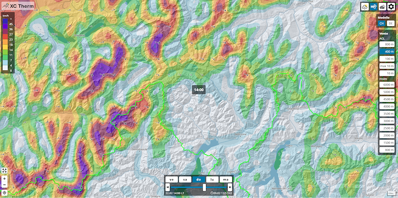
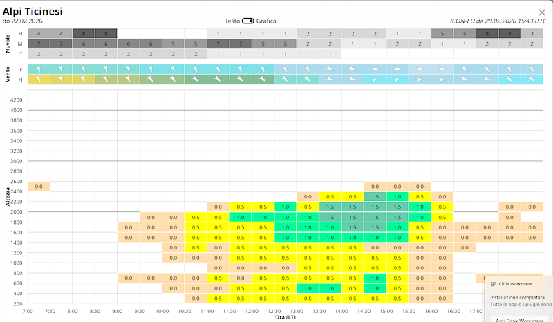
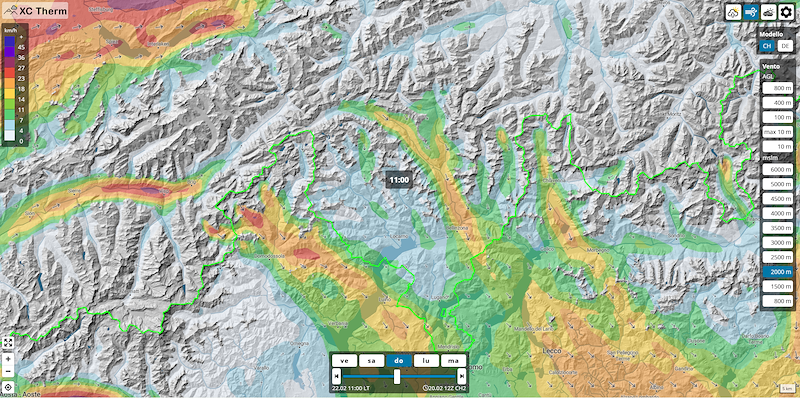
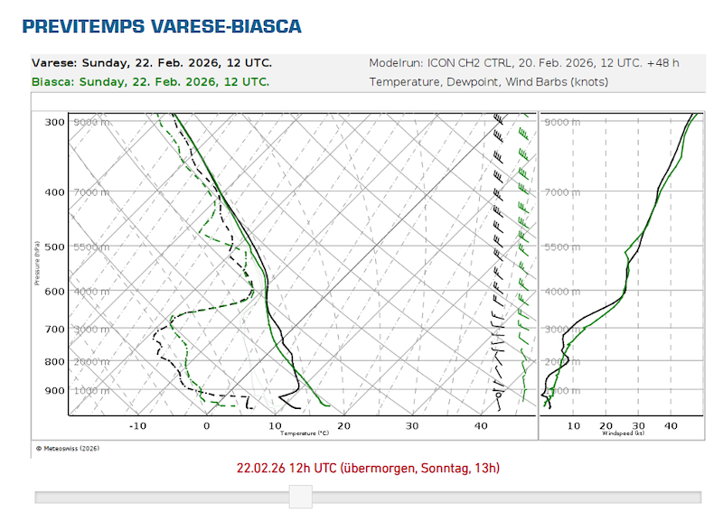
Le previsioni sono rimaste piuttosto simili a ieri, abbiamo un'incognita vento da nord-ovest che con il poco gradiente termico al mattino e magari dell'eventuale nuvolosità a media-alta quota può sfavorire i decolli nella neve, con vento non in favore. Soprattutto per quanto riguarda le alpi ticinesi. Questo ci porterebbe in qualsiasi caso ad un decollo tardivo, dalle 13:00 in poi.
Nel Dettaglio
Nuvolosità
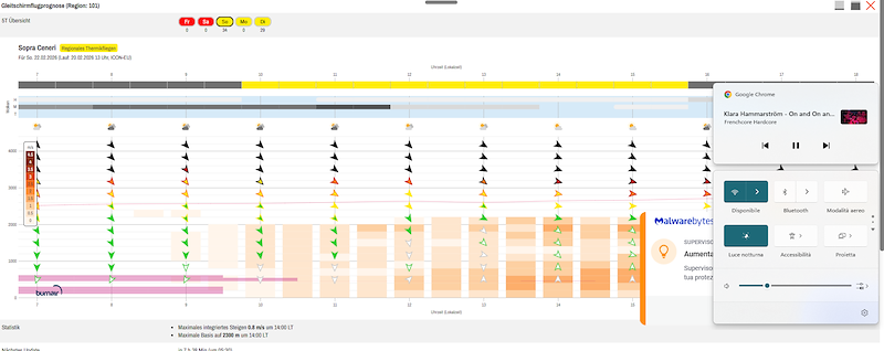
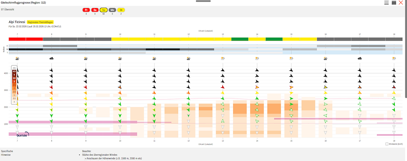
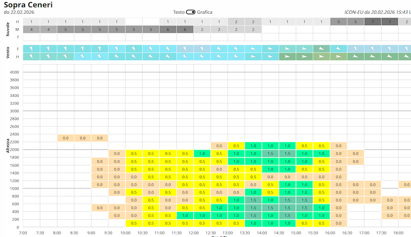
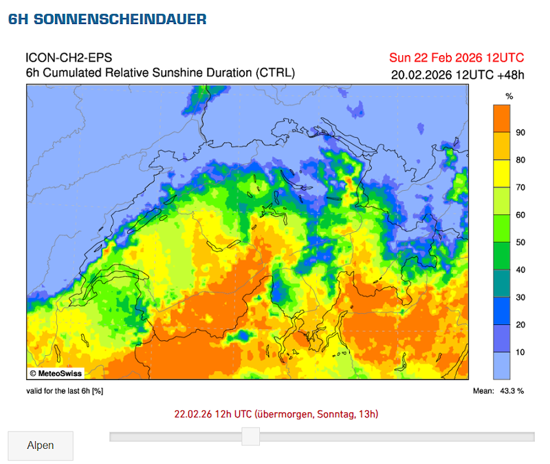
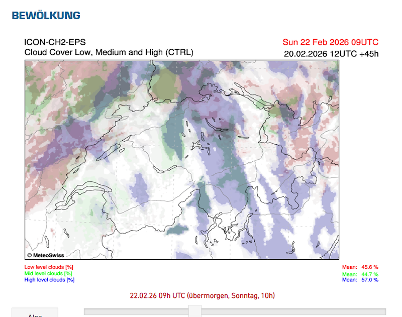
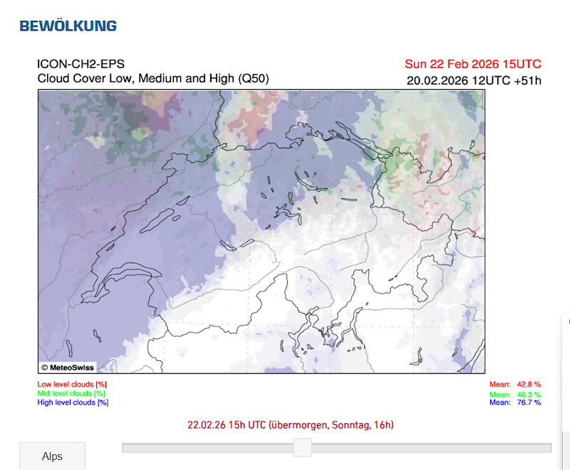
Da 2 a 4 ottani (2-3-4/8) nell'alto ticino, ma in migliormento. Da centro in gìù piu pulito con minime velature. Base massima a 2500m in alto ticino (anche se prevedo che se il gradiente è buono possa essere più alta, punto di rugiada in quota, Mentre più verso 2300-2400 massima per centro ticino.
Gradiente
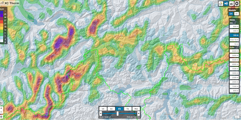
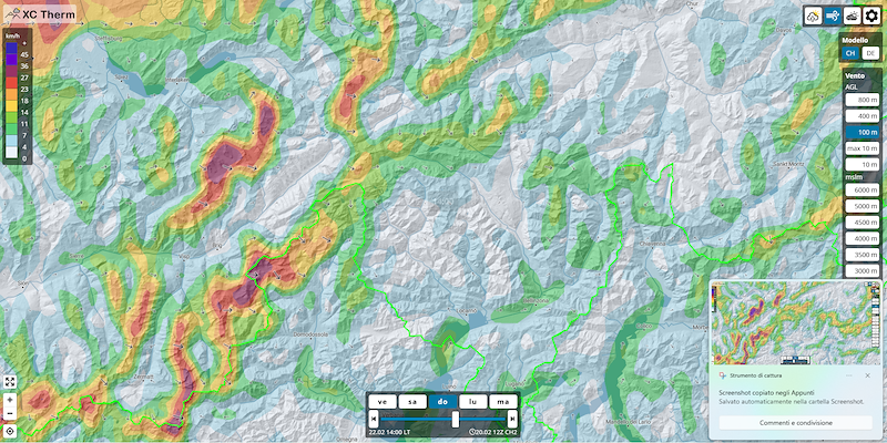
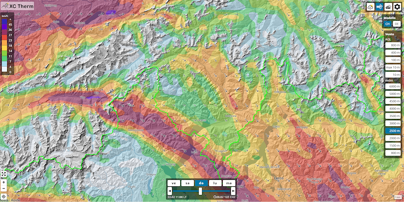
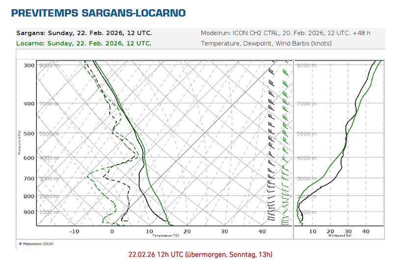
Dalle 13:00 per l'alto Ticino danno un gradiente in miglioramento con quasi 1°C/100m, che potrebbe creare termiche sportive, insieme all'aria in subsidenza causata dall'anticiclone in movimento sopra la svizzera. Ticino centrale c'è un gradiente di 0.5°C/100m, che però viene bloccato da diverse isotermie in movimento durante la giornata. Ma rimane anche in basso un possibile buon gradiente che si può sfruttare.
Vento
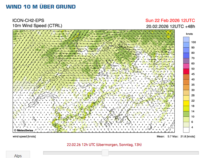
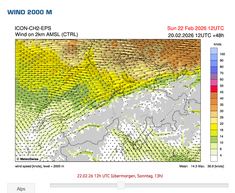
In alto Ticino c'è ancora una tendenza moderata da Nord-Ovest, alcuni modelli tutto il giorno con 15/20 km/h, alcuni solo fino alle 14. Il gradiente potrebbe permetterci di decollare ma potrebbe essere tricky al momento. In Ticino centrale siamo più riparati con il vento che non dovrebbe disturbare troppo.
Ricordo che le previsioni sono fatte in base alle condizioni e i modelli attuali. Ma mancano ancora 36 ore, di conseguenza c'è ancora molto tempo per cambiamenti. È complicato decidere su dove possa essere meglio, a causa della copertura in Leventina che magari potrebbe attivare il giorno troppo tardi e addirittura avere il rischio di non riuscire a decollare. Cimetta potrebbe essere la giocata più "safe" al momento.
Spero che vada bene per tutti se teniamo le opzioni aperte di Carì o Cimetta per la giornata domenica e domani alle 19:45 in punto un aggiornamento e conferma di Luogo e orari.
Saluti - Mattia e Ruben
--------------------------------------------------------------------
English
Let’s take another look at Sunday’s day.
The forecasts have remained quite similar to yesterday. We still have a north-west wind uncertainty which, together with the weak thermal gradient in the morning and possible mid to high-level cloud cover, could make snow take-offs unfavourable, with wind not aligned. Especially regarding the Ticino Alps. This would in any case lead to a late take-off, from 13:00 onwards.
In Detail
Cloud cover
From 2 to 4 oktas (2-3-4/8) in Upper Ticino, and from Central Ticino southwards clearer skies with slight high veils. Maximum base around 2500m in Upper Ticino (although I expect that if the gradient is good it could be higher, considering the dew point at altitude), while more around 2300–2400m maximum for Central Ticino.
Gradient
From 13:00 onwards in Upper Ticino, models show an improving gradient with almost 1°C/1000m, which could generate sporty thermals, together with subsiding air caused by the anticyclone moving over Switzerland. In Central Ticino there is a gradient of 0.5°C/1000m, which however is limited by several isothermal layers moving during the day. Nevertheless, there could still be a good low-level gradient to exploit.
Wind
In Upper Ticino there is still a moderate north-west tendency. Some models show 15–20 km/h throughout the day, some only until 14:00. The gradient might allow us to take off, but it could be tricky at the moment. In Central Ticino we are more sheltered, with wind that should not disturb too much.
I remind you that the forecasts are based on current conditions and models. However, there are still 36 hours to go, so there is still plenty of time for changes. It is complicated to decide where it might be better, due to the cloud cover in Leventina which could activate the day too late and even create the risk of not being able to take off. Cimetta could be the safest option at the moment.
I hope it works for everyone if we keep the options open for Carì or Cimetta for Sunday, and tomorrow at 19:45 sharp there will be an update and confirmation of location and schedule.
Best regards – Mattia and Ruben
----------------------------------------------------------------------------------------
Deutsch
Schauen wir uns den Sonntag nochmals genauer an.
Die Prognosen sind ziemlich ähnlich geblieben wie gestern. Es gibt weiterhin eine Unsicherheit bezüglich Nordwestwind, der zusammen mit dem schwachen Temperaturgradienten am Morgen und möglicher Bewölkung in mittleren bis hohen Schichten Schneestarts mit nicht günstigem Wind erschweren könnte. Besonders was die Tessiner Alpen betrifft. Dies würde in jedem Fall zu einem späten Start führen, ab 13:00 Uhr.
Im Detail
Bewölkung
2 bis 4 Oktas (2-3-4/8) im Oberen Tessin, und ab dem zentralen Tessin südwärts eher klar mit leichten Schleierwolken. Maximale Basis bei etwa 2500m im Oberen Tessin (wobei ich erwarte, dass sie bei gutem Gradient höher sein könnte, je nach Taupunkt in der Höhe), während sie im zentralen Tessin eher bei 2300–2400m liegen dürfte.
Gradient
Ab 13:00 Uhr zeigt sich im Oberen Tessin ein sich verbessernder Gradient mit fast 1°C/1000m, was sportliche Thermik ermöglichen könnte, zusammen mit absinkender Luft infolge des über die Schweiz ziehenden Hochdruckgebiets. Im zentralen Tessin liegt der Gradient bei 0.5°C/1000m, wird jedoch durch mehrere im Tagesverlauf wandernde Isothermien begrenzt. Dennoch bleibt auch in tieferen Schichten ein möglicherweise nutzbarer Gradient bestehen.
Wind
Im Oberen Tessin besteht weiterhin eine mässige Nordwesttendenz. Einige Modelle zeigen 15–20 km/h den ganzen Tag, andere nur bis 14:00 Uhr. Der Gradient könnte einen Start ermöglichen, jedoch ist es aktuell noch etwas heikel. Im zentralen Tessin sind wir besser geschützt, der Wind sollte dort weniger stören.
Ich erinnere daran, dass die Prognosen auf den aktuellen Bedingungen und Modellen basieren. Es sind jedoch noch 36 Stunden, daher ist noch viel Raum für Veränderungen. Es ist schwierig zu entscheiden, wo es besser sein könnte, da die Bewölkung in der Leventina den Tag eventuell zu spät aktivieren und sogar das Risiko mit sich bringen könnte, nicht starten zu können. Cimetta könnte derzeit die sicherere Option sein.
Ich hoffe, es ist für alle in Ordnung, wenn wir die Optionen Carì oder Cimetta für Sonntag offenhalten und morgen um 19:45 Uhr ein Update sowie die Bestätigung von Ort und Zeiten geben.
Freundliche Grüsse – Mattia und Ruben


New Comment